
 Wyoming State Trails Avalanche Hazard Maps
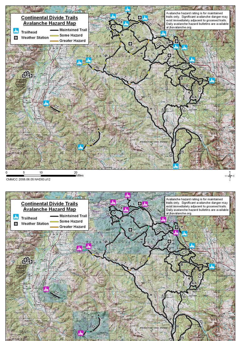
A Trail
The A Trail is 9 miles in length. It runs along portions of the South Fork of Warm Springs Creek and Salt Creek in its north south course from its junctions with the Continental Divide (CD) Trail 7 miles west of the Warm Springs Trailhead and 13 miles southwest of this trailhead near the Continental Divide. No known avalanche paths, steep banks or hillsides with significant potential to impact the groomed path of the A Trail have been identified.
Lake of the Woods (AA) Trail
The Lake of the Woods (AA) Trail is 3.0 miles in length. It connects the A trail with the Continental Divide (CD) Trail and crosses the Continental Divide near Lake of the Woods. No known avalanche paths, steep banks or hillsides with significant potential to impact the groomed path of the AA Trail have been identified.
Fish Lake Trail (B) Trail
The Fish Lake (B) Trail is 10.5 miles in length. It runs south and west from the Continental Divide (CD) Trail up Warm Spring Creek and Fish Lake Creek to Fish Lake, and then mostly east along the Continental Divide by Fish Lake Mountain to the A Trail. No known avalanche paths, steep banks or hillsides with significant potential to impact the groomed path of the B Trail have been identified.
Continental Divide (CD) Trail
The Continental Divide (CD) Trail runs from Yellowstone National Park to Sinks Canyon. This effort assessed the potential avalanche hazard along a 101mile section of this trail. This section runs east from the Black Rock Trailhead, over the Continental Divide at Togwotee Pass, down the east slope of the divide to the southeast past the Warm Springs Trailhead and then south and across the divide to the Upper Green River Trailhead.
There is one steep bank on the north side of the trail 0.8 miles west of the trailhead at Togwotee Mountain Lodge. This short bank can slide frequently and put some avalanche debris on the trail. This section of the CD Trail can be avoided during suspect conditions by taking the I Trail. No other known avalanche paths, steep banks or hillsides with significant potential to impact the groomed path of this 101 miles portion of the CD Trail have been identified.
Continental Divide Alternative (CDA) Trail
The CDA Trail is 6.5 miles in length and runs from a junction with the Continental Divide Trail near the Blackrock Trailhead to another junction with the Continental Divide Trail on the Flagstaff Road 7 miles west of Togwotee Mountain Lodge.
There is one steep bank on the south side of this trail 0.9 miles south of the junction with the CD Trail near the Blackrock Trailhead. This bank is 5.6 miles from the junction of this trail with the CD Trail on the Flagstaff Road. This north facing steep bank with a rock outcrop could be dangerous during unstable conditions. This area can be bypassed by traveling on the D and CD Trails if conditions warrant.
D Trail
The D Trail is 2 miles long. It is located south of the Blackrock Trailhead and connects the CD and the CDA Trails. No known avalanche paths, steep banks or hillsides with significant potential to impact the groomed path of the D Trail have been identified.
E Trail
The E Trail is 19 miles in length. It goes from the South Fork (K) Trail south and then east down to the West Fork of Fish Creek, and east over the Continental Divide, down to Sheridan Creek and then across the F Trail to the Continental Divide Trail. No known avalanche paths, steep banks or hillsides with significant potential to impact the groomed path of the portion of the E Trail mapped have been identified.
F Trail
The F Trail is 17 miles in length. It goes west along the Sheridan Trail from the Continental Divide Trail near the Tie Hack Trailhead to an overlook on the Continental Divide and southeast along the divide to the Fish Lake (B) Trail. No known avalanche paths, steep banks or hillsides with significant potential to impact the groomed path of the portion of the F Trail mapped have been identified.
Green River (GL) Trail
The Green River Lake (GL) Trail is 6.1 miles in length. It goes from the N Trail to Green River Lake. No known avalanche paths, steep banks or hillsides with significant potential to impact the groomed path of the portion of the GL Trail mapped have been identified.
I Trail
The I Trail is 2.5 miles in length. It parallels the Continental Divide Trail near Togwotee Mountain Lodge bypassing the Togwotee Mountain Lodge Trailhead.No known avalanche paths, steep banks or hillsides with significant potential to impact the groomed path of the I Trail have been identified.
J Trail
The J Trail is 10 miles in length. It goes from a junction with the Continental Divide Trail near the Tie Hack Trailhead to another junction with the Continental Divide Trail 1.5 miles west of the Warm Springs Trailhead. No known avalanche paths, steep banks or hillsides with significant potential to impact the groomed path of the J Trail have been identified.
JC Trail
The JC Trail is 1.5 miles in length. It connects the Continental Divide Trail to the J Trail. No known avalanche paths, steep banks or hillsides with significant potential to impact the groomed path of the JC Trail have been identified.
South Fork Creek (K) Trail
The South Fork (K) Trail is 18.1 miles in length. It goes from a junction with the Continental Divide Trail on the Flagstaff Road south, east and then northeast in the drainage of the South Fork of Spread Creek and then mostly north up Maverick Creek to a junction with the North Fork (V) Trail.
Avalanche Hazards: The primary avalanche hazard to this trail during unstable conditions is from steep slopes on both sides on the trail in the narrow upper reaches of Maverick Creek. These dangerous slopes are located 0.4 to 0.8 miles south of this trails junction with the North Fork (V) Trail. These slopes are 17.3 to 17.7 miles from the west end of this trail. The section of the trail that is 0.3 to 2.4 miles from the west end of the trail and 15.7 to 17.8 miles from the east end of the trail passes under several steep banks and steep slopes. These steep slopes and banks can slide and in some places could push and possibly bury a trail user into the creek along and below the trail. The trail crosses a short steep corniced bank on the north side of the trail 10.3 miles from the north/east end of the trail and 7.8 miles from the west end of the trail. This steep bank could slide and sweep a trail user into a creek on the south side of the trail.
Additional hazards are presented by a steep hillside on the north side of the trail 8.0 to 8.2 miles from the north end of the trail and 9.9 to 10.1 miles from the east end of this trail and a small steep bank located 14.7 miles from the north end of the trail and 3.4 miles for the east end of the trail.
Turpin Meadows (L) Trail
The Turpin Meadows (L) Trail is 8 miles in length. It runs from the Four Mile Meadows Trailhead north to Turpin Meadows Ranch and east to the Continental Divide Trail at Togwotee Mountain Lodge. No known avalanche paths, steep banks or hillsides with significant potential to impact the groomed path of the L Trail have been identified.
Crooked Creek Guest Ranch (LC) Trail
The Crooked Creek Guest Ranch (LC) Trail is 0.5 miles in length. It runs from the Crooked Creek Guest Ranch to the Lake Lodge (LL) Trail. No known avalanche paths, steep banks or hillsides with significant potential to impact the groomed path of the LC Trail have been identified.
Lake Lodge (LL) Trail
The Lake Lodge (LL) Trail is 1.7 miles in length. It runs from the Lake Lodge (LL) to the Continental Divide Trail at the Warm Springs Trailhead. No known avalanche paths, steep banks or hillsides with significant potential to impact the groomed path of the LL Trail have been identified.
MA Trail
The MA Trail is one mile in length. It runs along the north side of the Gros Ventre River Trail. No known avalanche paths, steep banks or hillsides with significant potential to impact the groomed path of the MA Trail have been identified.
Toppings Lake (MC) Trail
The Toppings Lake Trail is 6 miles in length. It goes east from the Toppings Lake Trailhead to Toppings Lake. This trail has not yet been assessed for avalanche hazards.
N Trail
The N Trail is 26 miles in length. It runs from the Continental Divide Trail up the Green River and then turns south up Moose Creek over a divide and then down Gypsum Creek to the Upper Green River Trailhead. No known avalanche paths, steep banks or hillsides with significant potential to impact the groomed path of the N Trail have been identified.O Trail
The O Trail runs from a junction on the Continental Divide Trail 5.5 miles south of the Blackrock Trailhead south to an abandoned well location. It also runs east from a junction north of the abandoned well location to the South Fork Creek (K) Trail.
There is a steep hillside 0.4 miles south of the north end of this trail. This hillside is on the west side of the trail above a road retaining wall on east of trail. This hillside area has potential to slide infrequently.
Elk Ridge Lodge (P) Trail
The Elk Ridge Lodge (P) Trail is 4.5 miles in length. It runs from the Upper Green River Trailhead west to the Elk Ridge Lodge and then north to the Continental Divide Trail. It goes along winter range where snowmobile access is restricted to the trail. No known avalanche paths, steep banks or hillsides with significant potential to impact the groomed path of the P Trail have been identified.
Pinnacle Buttes Lodge (PB) Trail
The Pinnacle Buttes Lodge (PB) Trail is 2.3 miles in length. It runs from the Pinnacle Buttes Lodge to the Continental Divide Trail. No known avalanche paths, steep banks or hillsides with significant potential to impact the groomed path of the PB Trail have been identified.
Gros Ventre River (R) Trail
The Gros Ventre River Trail is 45 miles in length. It runs from the Slide Lake Trailheads east and south along the Gros Ventre River and then up Kinky Creek and down Teepee Creek Drainage to a junction with the S Trail.
Avalanche Hazards: The primary avalanche hazard to this trail during unstable conditions is from south facing hillsides on the north side of the trail between the Slide Lake Trailheads. These south facing slopes are often bare or have shallow snow depths. When the snow is deep enough these hillside have some potential to slide across the trail. A southeast-facing hillside on the north side of the trail 4.2 miles east of the Lower Slide Lake Trailhead has some potential to slide during unstable conditions. A few steep banks along the south side of this trail - near a campground (5.2 to 5.5 miles east of the trailhead) - have some potential to slide during storm conditions.
S Trail
The S Trail is 19.5 miles in length. It goes from a junction with the Continental Divide Trail 8 miles north of the Upper Green River Trailhead to another junction with the Continental Divide Trail 20 miles north of this trailhead. No known avalanche paths, steep banks or hillsides with significant potential to impact the groomed path of the S Trail have been identified.
North Fork Fish Creek (T) Trail
The North Fork of Fish Creek (T) Trail is 22.6 miles in length. It goes from a junction with the Continental Divide Trail near Moccasin Basin south along the North Fork of Fish Creek to the Gros Ventre River Trail.
Avalanche Hazards: The primary avalanche hazard to this trail is from a active corniced slide path that crosses the trail 3.3 to 3.7 miles east its junction with the R Trail. This dangerous slide path is 11.5 to 11.7 miles south of this trails junction with the E Trail. This active slide path originates from a southeast-facing avalanche starting zone. It frequently crosses the trail and ends in a terrain trap on the southeast side of the trail.
A steep bank on the west side of the trail 3.3 to 3.5 miles south of the junction with the E Trail also has some potential to slide onto the trail during unstable conditions. This bank is located 11.3 to 11.5 miles east and north of the junction of this trails junction with the R Trail.
Triangle C Ranch (TC) Trail
The Triangle C Ranch (TC) Trail is 0.5 miles in length. It runs from the Triangle C Ranch to the Continental Divide Trail. No known avalanche paths, steep banks or hillsides with significant potential to impact the groomed path of the TC Trail have been identified.
Tie Hack (TH) Trail
The Tie Hack (TH) Trail is 0.7 miles in length. It runs from the Tie Hack Trailhead to the Continental Divide Trail. No known avalanche paths, steep banks or hillsides with significant potential to impact the groomed path of the TH Trail have been identified.
Lava Mountain (U) Trail
The Lava Mountain Trail is 3 miles in length. It runs from the E Trail north to an overlook on Lava Mountain. No known avalanche paths, steep banks or hillsides with significant potential to impact the groomed path of the TH Trail have been identified.
North Fork Creek (V) Trail
The North Fork (V) Trail is 10.3 miles in length. It goes east from a junction with the Continental Divide Trail on the Flagstaff Road along the drainage of the North Fork of Spread Creek past the top of Maverick Creek to a junction with the Continental Divide Trail in Squaw Basin.
Avalanche Hazards: The primary avalanche hazard to this trail during unstable conditions is from a steep bank on the north side of the trail located 1.2 miles from its eastern end and 9.1 miles from its western end.
Slate Creek / Dallas Fork (W) Trail
The Slate Creek/Dallas Fork (W) Trail is 12.7 miles in length. It goes north from the Gros Ventre River Trail across the Gros Ventre River, up Slate Creek and then northeast up Dallas Fork, over a divide and down to a junction with the South Fork (K) Trail.
Avalanche Hazards: The primary avalanche hazard to this trail during unstable conditions is from steep slopes on the west side of the trail located 0.9 to 1.3 miles south of the north end of this trail and 10.8 to 11. miles north of the south end of this trail. Additional hazards exist from a steep bank on the west side of the trail. This feature is located 10.3 miles from the north end of this trail and 2.4 miles from the south end of this trail.
Brooks Lake Lodge (X) Trail
The Brooks Lake Lodge (X) Trail is 14.5 miles in length. It goes east from a junction with the Continental Divide Trail in Squaw Basin up and over the Continental Divide via Togwotee Pass and then down the Brooks Lake Road past Barbers Point and Brooks Lake Lodge to the Brooks Lake Trailhead.
Avalanche Hazards: The primary avalanche hazard to this trail during unstable conditions is from a steep slope on the west side of this trail north of Barbers Point.
(XA) Trail
The XA Trail is 3 miles in length. It connects the Brooks Lake Lodge Trail to the Continental Divide Trail. No known avalanche paths, steep banks or hillsides with significant potential to impact the groomed path of the XA Trail have been identified.
Cache Creek (CC) Trail
The Cache Creek Trail is 6 miles in length. It goes southeast along Cache Creek from the Cache Creek Trailhead on the east side of Jackson.
Avalanche Hazards: Hillsides on the north side of this trail along the first mile and last mile of this trail have some potential to slide when unstable conditions exist.
Granite Hot Springs (G) Trail
The Granite Hot Springs (G) Trail is 9.2 miles in length. It goes from the Granite Hot Springs Trailhead in Hoback Canyon generally northeast along Granite Creek to Granite Hot Springs.
Avalanche Hazards: The primary avalanche hazard to this trail is from a very steep slope on the west side of the trail located 3.0 miles from the trailhead. This steep southeast-facing slope has several gullies that slide frequently across the trail into a terrain trap.
Additional hazards are associated with several steep banks and south facing hillsides on the north side of the trail at a distance of 1.2 to 1.8 miles from the trailhead. During unstable conditions these could slide across the trail into Granite Creek. This trail also crosses through the runout zone of a large avalanche path on the west side of the trail at a distance of 8.4 miles from the trailhead. This large avalanche path originates from a northeast-facing avalanche starting zone located at an elevation of 8,600 feet and would only run as far as the trail if this avalanche path ran full track.