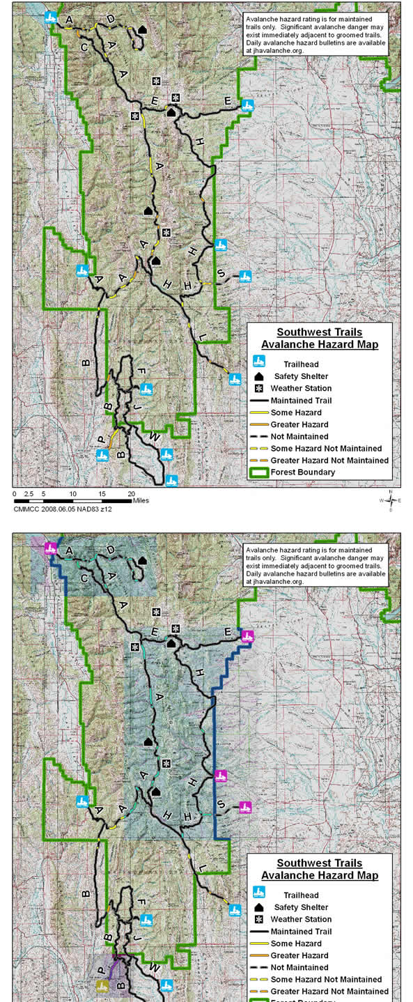

 Wyoming State Trails Avalanche Hazard Maps
Greys River Trail (A) Trail - From the Alpine to the Smith Fork Trailheads
The A Trail is 81 miles long and runs from a trailhead east of Alpine along the Greys River, almost to the Tri Basin Divide and then along the Smiths Fork River to the Smiths Fork Trailhead. For this mapping project it has been divided into three sections - Alpine to the Blind Bull Trail, Blind Bull Trail to Poison Creek Meadows and Smiths Fork Trailhead to Poison Creek Meadows (Smiths Fork Trail).
Greys River (A) Trail - Alpine to Blind Bull Trail
The northern section of the A Trail runs along the Greys River Road from a trail head in Alpine 25 miles to the east end of the Blind Bull Trail
Avalanche Hazards: The primary avalanche hazard to this trail during unstable conditions is from the Higgins Slide Path. This active path is located on the north side of the trail 5.2 miles east of the Alpine Trailhead and 2.1 miles west of the junction of the Greys River with the Little Greys River (A & D Trail Junction). This path is comprised of several gullies in a south-facing hillside that slide frequently (13 times during the 2007/08 season). If a trail user were caught in this slide they would likely be swept into the Greys River. A large avalanche in this area could include this entire slope. Several other slidepaths and numerous hillsides and banks exist in the stretch of trail from the bridge over the Greys River 1.6 miles east of the trailhead in Alpine to the junction of the A and D Trails.
The section of this trail from the Little Greys River to the east end of the Blind Bull Trail is threatened by one hillside that is 5.5 miles south of the Little Greys or 0.8 miles north of the junction of the south end of the C trail and the A trail.
Greys River (A) Trail - Blind Bull Trail to Poison Meadows
The interior section of the A Trail is 30.8 miles in length. It goes from the west end of the Blind Bull Trail to the Poison Meadows Safety Shelter. Except for the southernmost portion of this trail, which extends 3.3 miles north of the warming hut, this trail follows the Greys River Road. This detour from the road north of the warming hut avoids dangerous avalanche terrain.
Avalanche Hazards: The primary avalanche hazard to this trail during unstable conditions is from very steep hillsides on both sides of the trail in the "narrows" and several large avalanche paths on the east side of the trail south of Corral and Box Canyon Creeks. The very steep slopes in the "narrows" slide frequently and could bury trail users in the river. This dangerous section of the trail is located 27.1 miles south of the west end of the Blind Bull Trail and 3.7 miles north of the safety shelter. The large slide paths south of Corral and Box Canyon Creek are located 20 and 22 miles south of the west end of the Blind Bull Trail and 9 and 11 miles north of the safety shelter. Large dangerous avalanches could cross the trail from these west facing avalanche paths.
Numerous steep hillsides on the east side of the trail have some potential to slide during unstable conditions along the northern 16 miles of this portion of the A Trail. There is also a 2.6-mile section of this trail from the "narrows" north with steep banks and hillsides that could impact the trail.
Smith Fork (A) Trail - to Poison Meadows
The southern section of the A Trail goes 25.3 miles from the Smith Fork Trailhead to the Poison Meadows safety shelter. It follows the Smiths Fork Road east from the Trailhead over Commissary Ridge to the Tri Divide Basin and then north down the Greys River Road to the shelter.Avalanche Hazards: The primary avalanche hazards to this trail during unstable conditions are from avalanche paths on both sides of the Smiths Fork Road located 13 to 15 miles from the trailhead. Steep hillsides on the north side of this trail also exist above sections of this trail 8 to 9 miles and 10.8 to 11.5 miles from the trailhead. There is also a steep bank on the southwest side of the trail 6.4 miles from the trailhead and a steep open hillside that is traversed by the trail 18.3 miles from the trailhead.
Dry Fork (B) Trail
The Dry Fork or B Trail goes south from the A Trail along the Smiths Fork River for about 20 miles. It then goes east up Coal Creek, south along the Tunp Range and then south and southeast to the Viva Naughton Trailhead located 15 miles north of Kemmerer. The total length of this trail is 55 miles.
Avalanche Hazards: The primary avalanche hazard to this trail during unstable conditions is from a moderately steep slope on the west side of the trail in the Coal Creek Drainage. This slope is located 22 miles from the north end of the trail and about four miles west of this trails northern junction with the F Trail. This slope can have some cornice development along its top. It is situated at an elevation of 7,700 feet and faces east. The trail runs along the base of this slope with a significant terrain trap below the trail to the east.
A short hillside on the east side of the trail 3.0 miles south of its north end a short bank on the west side of the trail 4.7 miles south of its north end could be potential avalanche hazards during unstable conditions. These features are located 21.9 and 23.6 miles north of the northern F Trail Junction.
Squaw Creek to Murphy Creek (C) Trail
The C Trail provides an alternate route to the Greys River Road (A Trail) from Squaw Creek to Murphy Creek. It is 12.4 miles long.
Avalanche Hazards: The section of this trail that is 0.5 to 1.8 miles south of its junction with the A Trail at Squaw Creek (10.6 to 11.9 miles south of its junction with the A Trail at Murphy Creek) passes through the run out zones of some large active avalanche paths to the west and across some steep banks to the east.
At 0.5 and 0.6 miles south of the A Trail Junction at Squaw Creek the trail crosses beneath two large active avalanche paths. Debris from these slide paths can hit the trail with significant force. Avalanches in these paths originate from an elevation of 6,800 feet that face northeast. The runout zones of other large avalanche paths originating from east facing starting zones at elevations of 7,500 to 8,400 feet are crossed at 0.9, 1.0 and 1.5 miles south of this junction. From 1.5 to 1.8 miles south of this junction there is a steep bank on the east side of the trail which could slide across the trail and into terrain traps with a creek.
Little Greys River (D) Trail
The Little Greys River (D) Trail is 18 miles long. It runs from the intersection of the Greys and the Little Greys Rivers up the Little Greys River to McCain Meadow.
Avalanche Hazards: The primary avalanche hazard to this trail during unstable conditions are from steep hillsides located on the north and west side of the trail. A steep hillside 0.1 miles north of the junction of the Little Greys and Greys River Trails on the west side of the trail has some potential to slide to the trail during unstable conditions. At 0.4 miles north of this junction several large avalanches paths on the west side of the trail have the potential to run to the trail if a very large avalanche occurred. A steep hillside on the north side of the trail 2.8 to 3.2 miles from the junction has some potential to slide across the trail into the Little Greys River. Another steep gullied hillside exists above the north side of the trail and the river at mile 3.4. Steep hillsides above the river that also have some potential to slide under unstable conditions exist at miles 5.0, 6.3, 6.7, 7.6, 9.4 and 11.6. At several of these locations the potential exist for these hillsides to slide into the river. A steep bank on the north side of the trail 0.4 miles from the junction of this trail with itself also poses some hazard during unstable conditions.
Blind Bull Summit (E) Trail
The Blind Bull Summit or E Trail is 23 miles in length and crosses over the Wyoming Range from the Sherman Parking Area on its east end to the Greys River Road or A Trail on its west end. From the parking area it goes up the east side of the range via Horse Creek crosses over Blind Bull Summit at an elevation of 9,000 feet and then descends to the Greys River via Blind Bull Creek. A warming hut and an automated avalanche forecast weather station are located near Blind Bull Summit.
Avalanche Hazards: The primary avalanche hazard to this trail during unstable conditions is from a steep hillside located on the north side of the trail in the Blind Bull Drainage. This hillside is located 5.4 miles from the west end of the trail and 1.6 miles west of the warming hut. This hillside faces southeast and is at elevation of 8,900 feet.
F Trail
The F Trail is a 12.5-mile trail that forms a loop with a portion of the B Trail in the Big Park Area. No known avalanche paths, steep banks or hillsides with significant potential to impact the groomed path of the F Trail have been identified.
G Trail
The G Trail is 1.8 miles in length. It connects the F Trail to the Hams Fork River Road. No known avalanche paths, steep banks or hillsides with significant potential to impact the groomed path of the G Trail have been identified.
H Trail
The H Trail goes 32 miles north from the Middle Piney Creek Parking Area, 20 miles east of Big Piney, to the E Trail and 26 miles south and west from this parking area to its intersection with the A Trail near the Tri Basin Divide at the headwaters of the Greys River and La Barge Creek. Sections of the southern portion of this trial follow the historic route of the Lander Cut Off of the Emigrant Trail.
Avalanche Hazards: The primary avalanche hazard on the northern portion of this trail is located about 10.2 miles north of the parking area and 21.7 miles south of the north end of this trail. This area is just north of Bare Pass. In this area avalanches from a steep slope on the southwest side of the trail originate in northeast facing avalanche starting zones at an elevation of 9,200 feet. A steep bank along this trail 5 miles north of the parking areas could also present an avalanche hazard during unstable conditions.
On the southern portion of this trail there are several steep hillsides that could become potential avalanche hazards during unstable conditions. Steep hillsides on the east side of the trail in the Coal Creek Drainage could become an avalanche hazard if the had sufficient snow cover and conditions were unstable. These hillsides are 9.0 to 9.2 miles south of the parking area and 0.5 to 0.7 miles north of the H Trail junction with the S Trail. Another steep hillside on the east side of the trail and a short steep corniced hillside on the west side of the trail exist in the Coyote Park Creek Drainage. These features are located 6.8 and 7.2 miles south of the S Trail Junction and 0.3 and 0.7 miles north of the L Trail Junction.
On the western portion of this trail between its junction with the L and A Trails there is one place where the trail crosses a corniced drift above a very steep short drop into La Barge Creek. Under certain conditions this feature could become a dangerous terrain trap. If this feature appears to be questionable it is likely that it could be avoided by making an off trail detour. This spot is 6.0 miles northwest of this trails junction with the L Trail and about two miles southeast of the Tri Basin Divide.
J Trail
The J Trail is 11.3 miles in length. It connects the F Trail to the W and B Trails. No known avalanche paths, steep banks or hillsides with significant potential to impact the groomed path of the J Trail have been identified.
La Barge Creek (L) Trail
The La Barge Creek or L Trail begins at the La Barge Creek Parking Area 12 miles northwest of La Barge. It goes northwest along the La Barge Creek Road for 16 miles to its intersection with the H Trail at Coyote Park Creek.
Avalanche Hazards: The primary avalanche hazard to this trail is a known avalanche path located in very steep terrain on the southwest side of the trail between the Miller Creek and Cabin Creek Drainages. A large event in this active avalanche path could run across the trail. It is located 4.6 miles northwest of the trailhead and 11.3 miles southeast of the H Trail Junction. Avalanches on this path originate from a very steep northeast facing starting zone at an elevation of about 7,800 feet. About 0.2 miles northwest of this paths intersection with the trail is a very steep rocky slope on the northeast side of the trail. The long steep hillside faces southwest and is not always snow covered. If sufficient snow accumulated on this slope under unstable conditions there is some potential for an avalanche to impact the trail from this slope.
Another avalanche path has potential to impact the trail during unstable conditions from a steep open slope on the west side of the trail between the Indian Creek and Shafer Creek Drainages. This path is located 12.5 miles from the parking area and 3.4 miles form the H Trail Junction. A large avalanche on this east to northeast facing open slope has potential to reach the trail. The run out zone of this avalanche path can be avoided by traveling off the trail to the east in flatter terrain well away from this slope.
This trial goes along the base of a steep southwest-facing hillside one to two miles northwest of the parking area (13 to 14 miles from the H Trail Junction). If sufficient snow depths accumulated on this hillside there is some potential for snow slides to run to the trail in this area during unstable conditions.
Middle Pine Creek (M) Trail
The M Trail is 7 miles in length. It goes east along the Middle Piney Creek Road from the Middle Piney Creek Parking Area east towards Big Piney. No known avalanche paths, steep banks or hillsides with significant potential to impact the groomed path of the M Trail have been identified.
Pine Creek (P) Trail
The Pine Creek (P) Trail goes 4.9 miles from a trailhead at the Pine Creek Ski Area to a junction with the B trail.
Avalanche Hazards: Numerous active avalanche paths cross this trail along the first 1.9-mile section of this trail. The first half mile of this trial is the most dangerous with sizable avalanches originating from south and southeast facing avalanche paths to the west that frequently cross the trail. Avalanches from active slide paths; steep hillsides and banks to the west also could impact this trail in the section from 1.9 to 3.5 miles north of the trailhead.
South Piney Creek (S) Trail
The South Piney Creek or S Trail runs along the Lander Cut Off of the Emigrant Trail. It's east end is a parking area located approximately 13 miles west of Big Piney near Miami Ditch. From this parking lot it runs west 6.7 miles to a Junction with the H Trail at Coal Creek.
Avalanche Hazards: The primary avalanche hazard to this trail is from known avalanche paths that originate from very steep terrain on the north side of the trail 0.9 miles from the H Trail Junction and on both sides of the trail 1.0 mile east of the H Trail Junction. These slide paths are located 5.7 and 5.8 miles west of the parking area. Avalanches on the slide paths on the north side of the trail originate from starting zones at an elevation of 8,300 feet that face south. Avalanches on the path on the south side of the trail originate from starting zones at a similar elevation that face north.
Two other south facing hillsides along this trail have some potential to produce avalanches that could reach this trail when they are snow covered and conditions are unstable. One is located 0.3 miles form the H Trail Junction (6.4 miles from the parking area) and the other is located 1.3 miles from the H Trail Junction (5.4 miles from the parking area).
Willow Creek (T) Trail
The Willow Creek (T) Trail is 11 miles long. It goes from the Willow Creek Trailhead east and south up Willow Creek and to the south and west up White Pine Creek and down Phillips Creek to Grover. This trail has not yet been assessed for avalanche hazards.
Hams Fork (W) Trail
The Hams Fork Trail is 15.5 miles in length. It goes from the Viva Naughton Trailhead north and west to a junction with the J Trail. No known avalanche paths, steep banks or hillsides with significant potential to impact the groomed path of the W Trail have been identified.