
 Wyoming State Trails Avalanche Hazard Maps
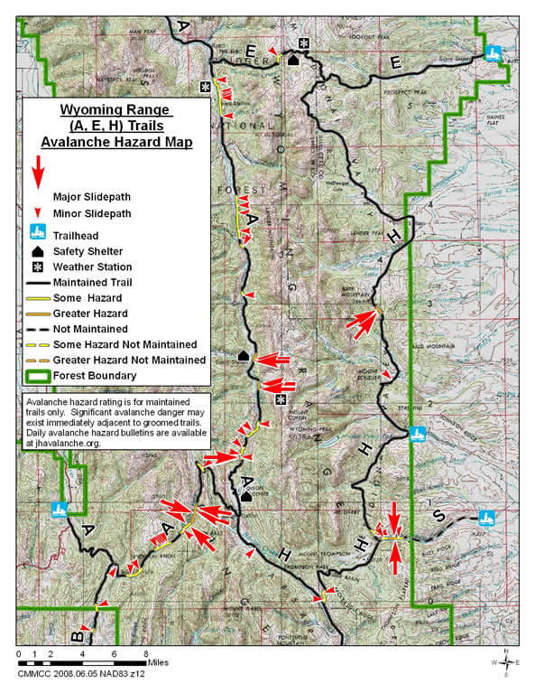
Greys River Trail (A) Trail - From the Alpine to the Smith Fork Trailheads
The A Trail is 81 miles long and runs from a trailhead east of Alpine along the Greys River, almost to the Tri Basin Divide and then along the Smiths Fork River to the Smiths Fork Trailhead. For this mapping project it has been divided into three sections: Alpine to the Blind Bull Trail, Blind Bull Trail to Poison Creek Meadows and Smiths Fork Trailhead to Poison Creek Meadows (Smiths Fork Trail).
Greys River (A) Trail - Alpine to Blind Bull Trail
The northern section of the A Trail runs along the Greys River Road from a trail head in Alpine 25 miles to the east end of the Blind Bull Trail
Avalanche Hazards: The primary avalanche hazard to this trail during unstable conditions is from the Higgins Slide Path. This active path is located on the north side of the trail 5.2 miles east of the Alpine Trailhead and 2.1 miles west of the junction of the Greys River with the Little Greys River (A & D Trail Junction). This path is comprised of several gullies in a south-facing hillside that slide frequently (13 times during the 2007/08 season). If a trail user were caught in this slide they would likely be swept into the Greys River. A large avalanche in this area could include this entire slope. Several other slidepaths and numerous hillsides and banks exist in the stretch of trail from the bridge over the Greys River 1.6 miles east of the trailhead in Alpine to the junction of the A and D Trails.
The section of this trail from the Little Greys River to the east end of the Blind Bull Trail is threatened by one hillside that is 5.5 miles south of the Little Greys or 0.8 miles north of the junction of the south end of the C trail and the A trail.
Greys River (A) Trail - Blind Bull Trail to Poison Meadows
The interior section of the A Trail is 30.8 miles in length. It goes from the west end of the Blind Bull Trail to the Poison Meadows Safety Shelter. Except for the southernmost portion of this trail, which extends 3.3 miles north of the warming hut, this trail follows the Greys River Road. This detour from the road north of the warming hut avoids dangerous avalanche terrain.
Avalanche Hazards: The primary avalanche hazard to this trail during unstable conditions is from very steep hillsides on both sides of the trail in the "narrows" and several large avalanche paths on the east side of the trail south of Corral and Box Canyon Creeks. The very steep slopes in the "narrows" slide frequently and could bury trail users in the river. This dangerous section of the trail is located 27.1 miles south of the west end of the Blind Bull Trail and 3.7 miles north of the safety shelter. The large slide paths south of Corral and Box Canyon Creek are located 20 and 22 miles south of the west end of the Blind Bull Trail and 9 and 11 miles north of the safety shelter. Large dangerous avalanches could cross the trail from these west facing avalanche paths.
Numerous steep hillsides on the east side of the trail have some potential to slide during unstable conditions along the northern 16 miles of this portion of the A Trail. There is also a 2.6 mile section of this trail from the "narrows" north with steep banks and hillsides that could impact the trail.
Blind Bull Summit (E) Trail
The Blind Bull Summit or E Trail is 23 miles in length and crosses over the Wyoming Range from the Sherman Parking Area on its east end to the Greys River Road or A Trail on its west end. From the parking area it goes up the east side of the range via Horse Creek crosses over Blind Bull Summit at an elevation of 9,000 feet and then descends to the Greys River via Blind Bull Creek. A warming hut and an automated avalanche forecast weather station are located near Blind Bull Summit.
Avalanche Hazards: The primary avalanche hazard to this trail during unstable conditions is from a steep hillside located on the north side of the trail in the Blind Bull Drainage. This hillside is located 5.4 miles from the west end of the trail and 1.6 miles west of the warming hut. This hillside faces southeast and is at elevation of 8,900 feet.
H Trail
The H Trail goes 32 miles north from the Middle Piney Creek Parking Area, 20 miles east of Big Piney, to the E Trail and 26 miles south and west from this parking area to its intersection with the A Trail near the Tri Basin Divide at the headwaters of the Greys River and La Barge Creek. Sections of the southern portion of this trial follow the historic route of the Lander Cut Off of the Emigrant Trail.
Avalanche Hazards: The primary avalanche hazard on the northern portion of this trail is located about 10.2 miles north of the parking area and 21.7 miles south of the north end of this trail. This area is just north of Bare Pass. In this area avalanches from a steep slope on the southwest side of the trail originate in northeast facing avalanche starting zones at an elevation of 9,200 feet. A steep bank along this trail 5 miles north of the parking areas could also present an avalanche hazard during unstable conditions.
On the southern portion of this trail there are several steep hillsides that could become potential avalanche hazards during unstable conditions. Steep hillsides on the east side of the trail in the Coal Creek Drainage could become an avalanche hazard if the had sufficient snow cover and conditions were unstable. These hillsides are 9.0 to 9.2 miles south of the parking area and 0.5 to 0.7 miles north of the H Trail junction with the S Trail. Another steep hillside on the east side of the trail and a short steep corniced hillside on the west side of the trail exist in the Coyote Park Creek Drainage. These features are located 6.8 and 7.2 miles south of the S Trail Junction and 0.3 and 0.7 miles north of the L Trail Junction.
On the western portion of this trail between its junction with the L and A Trails there is one place where the trail crosses a corniced drift above a very steep short drop into La Barge Creek. Under certain conditions this feature could become a dangerous terrain trap. If this feature appears to be questionable it is likely that it could be avoided by making an off trail detour. This spot is 6.0 miles northwest of this trails junction with the L Trail and about two miles southeast of the Tri Basin Divide.