
 Wyoming State Trails Avalanche Hazard Maps
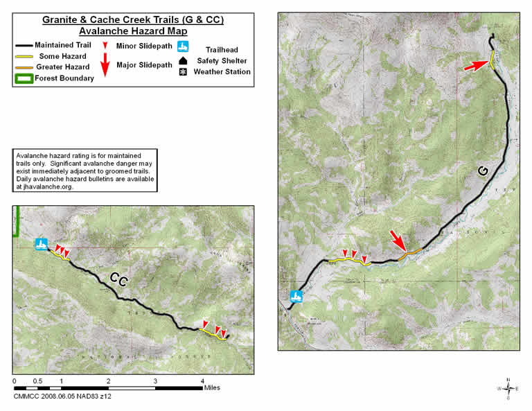
Cache Creek (CC) Trail
The Cache Creek Trail is 6 miles in length. It goes southeast along Cache Creek from the Cache Creek Trailhead on the east side of Jackson.
Avalanche Hazards: Hillsides on the north side of this trail along the first mile and last mile of this trail have some potential to slide when unstable conditions exist.
Granite Hot Springs (G) Trail
The Granite Hot Springs (G) Trail is 9.2 miles in length. It goes from the Granite Hot Springs Trailhead in Hoback Canyon generally northeast along Granite Creek to Granite Hot Springs.
Avalanche Hazards: The primary avalanche hazard to this trail is from a very steep slope on the west side of the trail located 3.0 miles from the trailhead. This steep southeast-facing slope has several gullies that slide frequently across the trail into a terrain trap.
Additional hazards are associated with several steep banks and south facing hillsides on the north side of the trail at a distance of 1.2 to 1.8 miles from the trailhead. During unstable conditions these could slide across the trail into Granite Creek. This trail also crosses through the runout zone of a large avalanche path on the west side of the trail at a distance of 8.4 miles from the trailhead. This large avalanche path originates from a northeast-facing avalanche starting zone located at an elevation of 8,600 feet and would only run as far as the trail if this avalanche path ran full track.