
 Wyoming State Trails Avalanche Hazard Maps
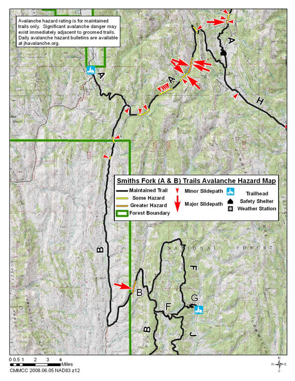
Greys River Trail (A) Trail - From the Alpine to the Smith Fork Trailheads
The A Trail is 81 miles long and runs from a trailhead east of Alpine along the Greys River, almost to the Tri Basin Divide and then along the Smiths Fork River to the Smiths Fork Trailhead. For this mapping project it has been divided into three section: Alpine to the Blind Bull Trail, Blind Bull Trail to Poison Creek Meadows and Smiths Fork Trailhead to Poison Creek Meadows (Smiths Fork Trail).
Smith Fork (A) Trail - to Poison Meadows
The southern section of the A Trail goes 25.3 miles from the Smith Fork Trailhead to the Poison Meadows safety shelter. It follows the Smiths Fork Road east from the Trailhead over Commissary Ridge to the Tri Divide Basin and then north down the Greys River Road to the shelter.Avalanche Hazards: The primary avalanche hazards to this trail during unstable conditions are from avalanche paths on both sides of the Smiths Fork Road located 13 to 15 miles from the trailhead. Steep hillsides on the north side of this trail also exist above sections of this trail 8 to 9 miles and 10.8 to 11.5 miles from the trailhead. There is also a steep bank on the southwest side of the trail 6.4 miles from the trailhead and a steep open hillside that is traversed by the trail 18.3 miles from the trailhead.
Dry Fork (B) Trail
The Dry Fork or B Trail goes south from the A Trail along the Smiths Fork River for about 20 miles. It then goes east up Coal Creek, south along the Tunp Range and then south and southeast to the Viva Naughton Trailhead located 15 miles north of Kemmerer. The total length of this trail is 55 miles.
Avalanche Hazards: The primary avalanche hazard to this trail during unstable conditions is from a moderately steep slope on the west side of the trail in the Coal Creek Drainage. This slope is located 22 miles from the north end of the trail and about four miles west of this trails northern junction with the F Trail. This slope can have some cornice development along its top. It is situated at an elevation of 7,700 feet and faces east. The trail runs along the base of this slope with a significant terrain trap below the trail to the east.
A short hillside on the east side of the trail 3.0 miles south of its north end a short bank on the west side of the trail 4.7 miles south of its north end could be potential avalanche hazards during unstable conditions. These features are located 21.9 and 23.6 miles north of the northern F Trail Junction.